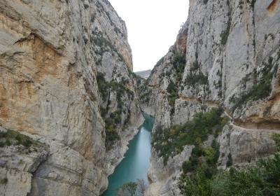
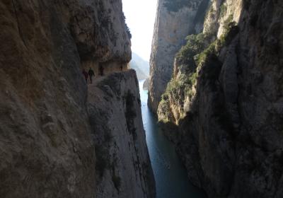
The twenty-fifth stage of the GR 1 Transversal Trail crosses the impressive serra del Montsec through the gorge that was carved out by the Noguera Ribagorçana River: the breathtaking Mont-rebei canyon. The path that has been into the rock face of the canyon lets you cross at the midway point, following along the cliff face. The monumental vertical rock walls of the canyon are the result of erosion by water over thousands of year, and its grandeur will leave you agape. Mont-rebei is the perfect ending to the great adventure that comes to an end in this stage.
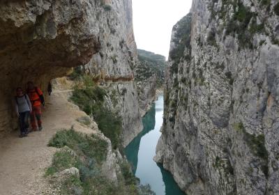
Average. Derived from the distance and ascent to overcome. Although the route through the canyon is not difficult technically, it can be dangerous since it follows a path carved into the rock face, with a width that ranges from 1m to 1.5m. The path is equipped with a handrail on attached to the rock face, but there is no railing on the outside edge and the drop down to the river ranges from 40m to 60m.
The whole year. In the winter, however, it can be quite cold in the canyon because there is not much sun. In the summer, in contrast, it is very hot. As such, we recommend getting a very early start.
We recommend carrying a pair of binoculars: it is likely that you will be able to observe large and small birds of prey as well as crag martins or rock pigeons.
Congost de Mont-rebei. 1:20,000. Editorial Alpina.
Topographic map of Catalonia 1:25,000. Institut Cartogràfic i Geològic de Catalunya (ICGC).
We begin the twenty-fifth stage of the GR 1 at (1) Mas Carlets (0:00 - 750 m). Leave the building and take the narrow path into the canyon of Mont-rebei (N). You will descend through a forest, gradually approaching the orographic left bank of the river. Soon you will come to the Montfalcó fork. On your left, you will pass a path that crosses the river via a metallic suspension bridge, which provides a connection, on foot, between the Montsec d'Ares (Catalonia) and the Montsec d'Estall (Aragon). On the far bank of the river you will see the dizzying wooden footpaths that create a route up and down the face of the cliff.
Continue straight ahead, beginning to ascend. Before long you will see the entrance to the (2) Mont-rebei ravine (0:35 - 540 m). Continue along the path carved into the rock. This path requires careful attention. It is only equipped with a handrail on the inside of the rock face. There is no railing on the outside of the cliff. You should also look out for falling rocks, as natural rockslides can occur. From the first moment, the canyon will amaze you; the rock walls swallow you as you follow the path, which is quite narrow in some areas.
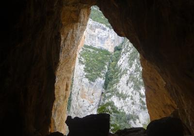
Near the middle of the canyon, you will see hidden to your right a very narrow path that ascends steeply between holm oaks and box plants to the Colomera cave. Leave the main route for a while to turn onto this steep and narrow path. There are a few sections equipped with stairs and chain railings. Using your hands and following the stone markers, in about 10 minutes you will arrive at the Colomera cave, a very high and deep cavity that is very worthwhile to visit.
Afterward, head back to the main path through the Mont-rebei canyon. You will go through a tunnel and continue crossing the canyon. Slowly the canyon will begin to open and the path will turn toward the right (E). You will arrive at the Fondo ravine and cross it via the (3) Sant Jaume suspension bridge (1:00 - 496 m). Continue skirting the water’s edge. If you look to your left, on the other side of the river and above a cliff you will see two constructions from the 11th century that overlook the northern entrance to the canyon: one is religious and the other is military. The first is the Romanesque hermitage of Mare de Déu del Congost; the second is the Girbeta castle, also known as the Moors’ castle.
You will arrive at the (4) la Masieta recreation area (1:30 - 512 m), a space with a large parking area, an information booth, restrooms and a number of picnic tables. Continue along the access road to la Masieta until you reach the road that connects Sant Esteve de la Sarga and Pont de Montanyana. From this point until reaching Pont de Montanyana, the route follows the road. Take the road to the left (N) and follow it, being careful of any passing cars. You will see an intersection with GR 1-4, coming from the northern side of the Montsec.
Finally, you will emerge onto (5) road number C-1311 (3:00 - 550 m). Follow this road for a few meters and quickly turn onto the path that leads to Pont de Montanyana (right). After a few minutes you will reach the plaça de l’ajuntament of (6) Pont de Montanyana (3:10 - 532 m), endpoint of the Catalan section of the impressive GR 1 Transversal Trail.
Walking through the middle of the Mont-rebei canyon, on the path carved into the rock face.
Stepping of the main trail to visit the Colomera cave.
Observing the clear difference between the two slopes of the Montsec.
Aragon and Catalonia are connected again thanks to the hanging walkways of Canelles-Montfalcó? 60 years have passed since the old bridge that connected the two banks of the Noguera Ribagorçana River was flooded to build the reservoir. Now, the new walkway lets people cross between the two banks.
Visiting the Colomera cava and discovering 8,000-year-old traces of prehistoric inhabitants, and imagining what life would have been like there during the Neolithic. If you enter farther into the cave you will see deep holes covered in white spots – the excrement of a colony of rock pigeons who make their nests in the many hidden holes in the walls of the cave.


